


Henry Burbeck was an artillery officer serving under Anthony Wayne, stationed at Fort Jefferson in 1792. An amateur archaeologist was going through the trash of a descendant of the Burbeck family and recovered some Burbeck papers, including this drawing of Fort Jefferson. They were donated to West Point in 1986. The drawings were either made by Burbeck or, at least, created around 1792.
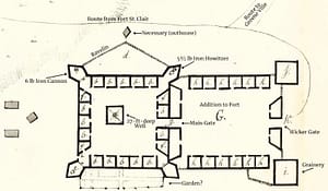
We know how to date the drawing because General Wilkinson built a large house for Mrs. Wilkinson, inside the fort, who moved to Fort Jefferson on 19 October 1793. The drawing also helps us position the fort on the Fort Jefferson grounds.
In 1930, during a cosponsored archaeology dig by Darke County Historical Society and the Ohio State Archaeological Society, they uncovered what was believed to be a Blockhouse just outside the ravelin to the north. After examining the site’s 1930 dig photos and comparing them to this drawing of the fort, it is thought that the so-called blockhouse was actually a necessary (outhouse) where soldiers could relieve themselves.
It is also noted where the placements were for the two iron cannons left for fort defense. The heavy, long-barreled six-pound iron cannon was in the northwest corner bastion, and the shorter-barreled 5.5-inch Howitzer was in the fort’s northeast bastion. The Howitzer was lighter and easier to move to other bastions. During recent metal detector surveys, fragments of the Howitzer shells have been found on three sides of the fort. The six-pound cannon fired canisters holding about 54 small one-inch iron balls that were delivered shotgun style at the enemy. Over fifty of these small balls have been recently recovered north and west of the fort.
The drawing also confirms that the road south of Fort Jefferson approaches the fort from the west side of Prairie Creek and shows the route to Greene Ville. When Rt. 121 was built, it took a lot of fill to get through the swampy area south of Fort Jefferson. A recent investigation of that swampy area shows Brush Creek used to flow west through the low spot on the Route 121, and has been filled in. Brush Creek now flows north on the east side of the Route. 121.
The small structure at the bottom of the main fort seems to be a garden.
Friends of Fort Jefferson thanks Wayne’s Legion Research Group for all their volunteer help. Many artifacts have been found, researched, cleaned, cataloged, and are now held for Friends of Fort Jefferson until a suitable spot for permanent display is arranged.
Also, thanks to the landowners who have allowed us to explore their land. They have significantly contributed to our understanding of Fort Jefferson.
FOFJ plans to keep researching government records for more compelling stories about our nation’s origins and the significance of Fort Jefferson.
Our motto is “REMEMBER FORT JEFFERSON”.